Fachbereich Geowissenschaften


Springe direkt zu: Inhalt


Service-Navigation


Hauptnavigation/Hauptmenü: Links auf direkt erreichbare, übergeordnete Webseiten


Grafischer Identitätsbereich:

Planetologie / Fernerkund.

Weitere Service-Funktionen


Navigation/Menü: Links auf weitere Seiten dieser Website und Banner


30.08.2006

HRSC Produktserie #290 - Kasei Valles Orbit 1429

HRSC Press Release #290 - Kasei Valles (orbit 1429)
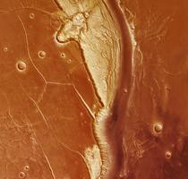

RGB Farbbild: Kasei Nord
Am 26. Februar 2005 nahm die hochauflösende Stereokamera (HRSC) auf der ESA-Sonde Mars Express im Orbit 1429 einen Teil der Region Kasei Valles mit einer Auflösung von 29 Metern pro Bildpunkt auf. Die Abbildungen zeigen zwei Ausschnitte zwischen 21° und 28° nördlicher Breite bei 292,5° östlicher Länge.

On 26 February 2005 the High-Resolution Stereo Camera (HRSC) onboard the ESA spacecraft Mars Express obtained image data in orbit 1429 with a ground resolution of approximately 29 metres per pixel. The data were acquired in the region of Kasei Valles, between 21° and 28° northern latitude at 292.5° eastern longitude.
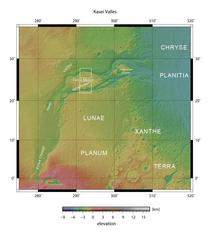


Kontextkarte
Kontextkarte
Kasei Valles ist eines der größten Ausflusstalsysteme des Mars, welches wahrscheinlich durch gigantische Flutereignisse geformt wurde. Eine Überprägung durch Gletschertätigkeit ist wahrscheinlich. Die Kasei Valles bilden die Verbindung zwischen dem südlich gelegenen Echus Chasma und der Ebene Chryse Planitia im Osten (Landestelle Viking 1 und Pathfinder). Das System der Kasei Valles erreicht eine Breite von etwa 500 Kilometern und erstreckt sich zusammen mit Echus Chasma über eine Länge von ungefähr 2500 Kilometern. Die in den Abbildungen gezeigten Talarme erreichen dort eine Tiefe von etwa 2900 Metern.

Kasei Valles is one of the biggest outflow channel systems on Mars, and which probably has been formed by gigantic flood events. It was additionally shaped by glacial activity. Connecting the southern Echus Chasma and the plain Chryse Planitia in the east, Kasei Valles has a width of roughly 500 kilometres and, if Echus Chasma is included, extends for approximately 2500 kilometres. Both valley branches shown in the image scenes exhibit a depth of 2900 metres.


Kasei Nord

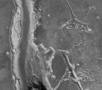
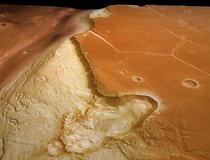
Die erste Szene zeigt den nördlichen Arm von Kasei Valles und die Ebene Sacra Mensa. Am westlichen Rand der Szene fällt eine ovale Struktur auf, die wahrscheinlich von einem flachwinkligen Meteoriteneinschlag verursacht wurde.
Perspektive: Kasei Nord #2

In the first scene the northern branch of Kasei Valles and the plain Sacra Mensa can be seen. An oval structure at the western edge of the scene is interpreted as a crater caused by an oblique meteorite impact.
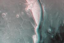
Rot-Cyan Anaglyphe: Kasei Nord
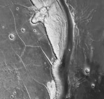
Nadiraufnahme: Kasei Nord


Kasei Süd

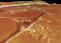
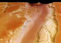
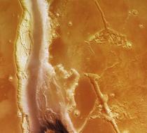
Die zweite Szene zeigt den südlichen Arm von Kasei Valles neben Sacra Mensa mit ihrem ein bis zwei Kilometer tiefen Grabensystem Sacra Fossae. An beiden Seitenhängen des Talarms sind bis zu 30 Kilometer breite Terrassen erkennbar.
Perspektive: Kasei Süd #1

The southern branch of Kasei Valles and Sacra Mensa with its 1-2 kilometres deep graben system Sacra Fossae is shown in the second scene. Up to 30 kilometres wide are the terraces which follow the slopes on both sides of the valley branch.
RGB Farbbild: Kasei Süd
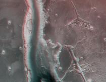
Rot-Cyan Anaglyphe: Kasei Süd


Nadiraufnahme: Kasei Süd
Die Farbansichten wurden aus dem senkrecht blickenden Nadirkanal und den Farbkanälen erstellt, die Schrägansicht wurde aus den Stereokanälen der HRSC berechnet. Die Anaglyphen werden aus dem Nadirkanal und einem Stereokanal abgeleitet. Die schwarzweißen Detailaufnahmen wurden dem Nadirkanal entnommen, der von allen Kanälen die höchste Auflösung zur Verfügung stellt.

The colour scenes have been derived from the three HRSC-colour channels and the nadir channel. The perspective views have been calculated from the digital terrain model derived from the stereo channels. The anaglyph image was calculated from the nadir and one stereo channel. The black and white high resolution images were derived form the nadir channel which provides the highest detail of all channels.
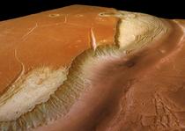

Perspektive: Kasei Nord #1
Das Kameraexperiment HRSC auf der Mission Mars Express der Europäischen Weltraumorganisation ESA wird vom Principal Investigator Prof. Dr. Gerhard Neukum (Freie Universität Berlin), der auch die technische Konzeption der hochauflösenden Stereokamera entworfen hatte, geleitet. Das Wissenschaftsteam besteht aus 40 Co-Investigatoren aus 33 Institutionen und zehn Nationen. Die Kamera wurde am Deutschen Zentrum für Luft- und Raumfahrt (DLR) unter der Leitung des Principal Investigators (PI) G. Neukum entwickelt und in Kooperation mit industriellen Partnern gebaut (EADS Astrium, Lewicki Microelectronic GmbH und Jena -Optronik GmbH). Sie wird vom DLR -Institut für Planetenforschung in Berlin-Adlershof betrieben. Die systematische Prozessierung der Daten erfolgt am DLR. Die Darstellungen wurden vom Institut für Geologische Wissenschaften der FU Berlin in Zusammenarbeit mit dem DLR-Institut für Planetenforschung erstellt.

Perspektive: Kasei Süd #2
The High Resolution Stereo Camera (HRSC) experiment on the ESA Mars Express Mission is led by the Principal Investigator (PI) Prof. Dr. Gerhard Neukum who also designed the camera technically. The science team of the experiment consists of 40 Co-Investigators from 33 institutions and 10 nations. The camera was developed at the German Aerospace Center (DLR) under the leadership of the PI G. Neukum and built in cooperation with industrial partners (EADS Astrium, Lewicki Microelectronic GmbH and Jena-Optronik GmbH). The experiment on Mars Express is operated by the DLR Institute of Planetary Research, through ESA/ESOC. The systematic processing of the HRSC image data is carried out at DLR. The scenes shown here were created by the PI-group at the Institute for Geological Sciences of the Freie Universitaet Berlin in cooperation with the German Aerospace Center (DLR), Institute of Planetary Research, Berlin.


Download
hochaufgelöste Bilddaten / high resolution image data

Kontextkarte:   TIF
(4 MBs)
JPG
(145 KBs)
Nadiraufnahme: Kasei Nord:   TIF
(24 MBs)
JPG
(4 MBs)
Nadiraufnahme: Kasei Süd:   TIF
(26 MBs)
JPG
(4 MBs)
RGB Farbbild: Kasei Nord:   TIF
(72 MBs)
JPG
(3 MBs)
RGB Farbbild: Kasei Süd:   TIF
(75 MBs)
JPG
(3 MBs)
Rot-Cyan Anaglyphe: Kasei Nord:   TIF
(49 MBs)
JPG
(2 MBs)
Rot-Cyan Anaglyphe: Kasei Süd:   TIF
(92 MBs)
JPG
(3 MBs)
Perspektive: Kasei Nord #1:   TIF
(47 MBs)
JPG
(2 MBs)
Perspektive: Kasei Nord #2:   TIF
(50 MBs)
JPG
(2 MBs)
Perspektive: Kasei Süd #1:   TIF
(47 MBs)
JPG
(1 MB)
Perspektive: Kasei Süd #2:   TIF
(47 MBs)
JPG
(1 MB)

© Copyright: ESA/DLR/FU Berlin (G. Neukum)


© 2003 - 2024 Fachbereich Geowissenschaften Berlin 
Stand: 18.07.2012

Diese Grafiken werden nur in der Druckvorschau verwendet: