Navigation/Menü: Links auf weitere Seiten dieser Website und Banner
29.04.2005
HRSC Press Release #168 - Tithonium Chasma details (orbit 0887)
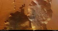 Am 28. September 2004 nahm die hochauflösende Stereokamera (HRSC) auf der ESA
Sonde Mars Express Bilddaten aus dem Bereich des Tithonium Chasma mit einer
Auflösung von etwa 13 Metern/Bildpunkt auf.
On 28 September 2004 the High Resolution Stereo Camera (HRSC) onboard the ESA
spacecraft Mars Express obtained image data in orbit 887 with a ground
resolution of approximately 13 meters per pixel. The images cover Tithonium
Chasma at approximately 5° southern latitude and 280° eastern longitude.
Das Tithonium Chasma liegt bei etwa 5° südlicher Breite und 280° östlicher Länge
und bildet ein Ost-West verlaufendes Tal im westlichen Valles Marineris,
parallel zu Ius Chasma. Das Tal erreicht eine Breite von etwa 10 km im Osten bis
maximal 110 km im Westen und besitzt eine Tiefe von bis zu 4 km.
Tithonium Chasma, a major trough in the western region of Valles Marineris,
extends roughly from east to west and runs parallel to Ius Chasma. The trough,
ranging from approximately 10 km to 110 km wide, narrows in an easterly
direction and has a maximum depth of about 3.5 km to 4.0 km.
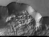 In den Bilddaten sind im östlichen Bereich des Tithonium Chasma eine Vielzahl
von Hangprozessen zu erkennen. An der nördlichen Wand des Chasma ist eine
größere Rutschung abgegangen, die sich bis zu 10 km in die Talmitte
erstreckt. Der Talboden und einige Kraterebenen im zentralen Teil des
Bildausschnittes sind vielfach von kleineren Dünenfelder überprägt.
By extending deep into the Martian surface, Valles Marineris provides a window
into geologic and climactic history of the planet. Valles Marineris has a
complex evolution and has been shaped by tectonic, volcanic and glacial
processes as well as fluvial and eolian erosion.
The color image shows a region in the eastern part of Tithonium Chasma. Along
the slopes of the trough, linear feature attributed to erosion are visible. At
the base of the northern wall, an apron of material, which exhibits a
longitudinal ridge pattern, may have been caused by a massive landslide.
Dune fields are scattered throughout the trough, including the northeast
portion of a crater.
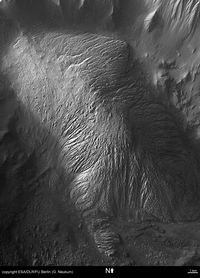 Im östlichen Talabschnitt ist ein stark gerunderter und deutlich erodierter
Restberg zu erkennen, der sich in Nordwest-Südost Richtung erstreckt. Die
linearen und deutlich herauspräparierten Erosionserscheinungen auf seiner
Oberfläche lassen die Vermutung auf die Erosion einer strukturell
vorgeprägten Oberfläche durch Wind oder Wasser zu.
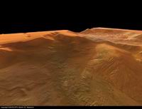
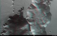
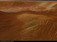
Within the eastern part of the trough, an interesting hill exhibits linear
features. These structures are highlighted in the close-up and perspective views
and most likely caused by fluvial or eolian erosion. The darker material to the
south of this hill is thought to be underlying material that has been
exposed by wind erosion.
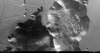 Auf der südlichen Grabenschulter sind Nord-Süd verlaufende tektonische Gräben zu
erkennen, die mit der Aufwölbung von Tharsis in einem genetischen
Zusammenhang stehen könnten.
A string of depressions on the plains in the southwest of the image may be
caused by surface collapse. These features are common to this region and extend
parallel to Valles Marineris. Nearby, prominent linear features are visible and
may be faults associated with the formation of the Tharsis Rise, located to the
west of Valles Marineris and extending to a height of 8 to 10 km. Some of these
faults can be seen faintly extending into the trough.
 Die Farbansichten wurden aus dem senkrecht blickenden Nadirkanal und den Farbkanälen erstellt, die Schrägansicht wurde aus den Stereokanälen der HRSC berechnet. Die Anaglyphen werden aus dem Nadirkanal und einem Stereokanal abgeleitet. Die schwarzweißen Detailaufnahmen wurden dem Nadirkanal entnommen, der von allen Kanälen die höchste Auflösung zur Verfügung stellt.
The colour scenes have been derived from the three HRSC-colour channels and the nadir channel. The perspective views have been calculated from the digital terrain model derived from the stereo channels. The anaglyph image was calculated from the nadir and one stereo channel. The black and white high resolution images were derived form the nadir channel which provides the highest detail of all channels.
 Das Kameraexperiment HRSC auf der Mission Mars Express der
Europäischen Weltraumorganisation ESA wird vom Principal Investigator Prof. Dr.
Gerhard Neukum (Freie Universität Berlin), der auch die technische Konzeption der
hochauflösenden Stereokamera entworfen hatte, geleitet. Das
Wissenschaftsteam besteht aus 40 Co-Investigatoren aus 33 Institutionen und zehn
Nationen. Die Kamera wurde am Deutschen Zentrum für Luft- und Raumfahrt (DLR) unter der
Leitung des Principal Investigators (PI) G. Neukum entwickelt und in Kooperation mit
industriellen Partnern gebaut (EADS Astrium, Lewicki Microelectronic GmbH und Jena
-Optronik GmbH). Sie wird vom DLR -Institut für Planetenforschung in Berlin-Adlershof
betrieben. Die systematische Prozessierung der Daten erfolgt am DLR. Die Darstellungen
wurden vom Institut für Geologische Wissenschaften der FU Berlin in Zusammenarbeit
mit dem DLR-Institut für Planetenforschung erstellt.
 The High Resolution Stereo Camera (HRSC) experiment on the ESA Mars Express Mission is led by the
Principal Investigator (PI) Prof. Dr. Gerhard Neukum who also designed the camera technically. The
science team of the experiment consists of 40 Co-Investigators from 33 institutions and 10 nations.
The camera was developed at the German
Aerospace Center (DLR) under
the leadership of the PI G. Neukum and built in cooperation with industrial partners (EADS
Astrium, Lewicki Microelectronic GmbH and Jena-Optronik GmbH). The experiment on Mars Express
is operated by the DLR Institute of Planetary Research, through ESA/ESOC. The systematic
processing of the HRSC image data is carried out at DLR. The scenes shown here were created
by the PI-group at the Institute for Geological Sciences of the Freie Universitaet Berlin in
cooperation with the German Aerospace Center (DLR), Institute of Planetary Research, Berlin.
© Copyright: ESA/DLR/FU Berlin (G. Neukum)
Download
hochaufgelöste Bilddaten / full resolution image data
Nadiraufnahme / Grayscale Nadir Image | download TIF ( 42.7 MBs ) |
Nadiraufnahme (Detail) / Nadir Image (detail) #2 | download TIF ( 3.3 MBs ) |
Nadiraufnahme (Detail) / Nadir Image (detail) #3 | download TIF ( 7.9 MBs ) |
RGB Farbbild / RGB Colour Image | download TIF ( 127.3 MBs ) |
Rot-Cyan Anaglyphe / Red-cyan anaglyphe | download TIF ( 144.5 MBs ) |
Perspektive / Perspective view | download TIF ( 49.4 MBs ) |
Perspektive #2 / Perspective view #2 | download TIF ( 50.7 MBs ) |

 English

