Navigation/Menü: Links auf weitere Seiten dieser Website und Banner
28.07.2005
HRSC Press Release #209 - Crater Ice (orbit 1343)
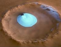 Am 2. Februar 2005 nahm die hochauflösende Stereokamera HRSC auf der ESA-Sonde
Mars Express im Orbit 1343 einen Bereich der Oberfläche in der nördlichen
Tiefebene Vastitas Borealis mit einer Auflösung von etwa 15 Metern pro Bildpunkt
auf. Die Abbildungen zeigen einen Einschlagskrater bei 70.5° nördlicher Breite
und 103° östlicher Länge.
On 2 February 2005 the High-Resolution Stereo Camera (HRSC) onboard the ESA
spacecraft Mars Express obtained image data in orbit 1343 with a ground
resolution of approximately 15 meters per pixel. The data were acquired in the
region of Vastitas Borealis, at approximately 70.5° northern latitude and 103°
eastern longitude.
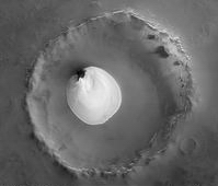 Im Zentrum des etwa 35 km großen Kraters sticht farblich das weiße residuale
Wassereis deutlich hervor. Wassereis kann sich ganzjährig dort halten ohne
vollständig zu sublimieren (vom festen in den gasförmigen Zustand übergehen),
da die Temperaturen und der atmosphärische Druck dazu nicht aureichen.
Kohlendioxideis ist zur Zeit der Bildaufnahme (später Mars Sommer) bereits
auch von der gesamten Nordpolkappe verschwunden, so dass nur noch Wassereis
vorhanden ist. Die Höhendifferenz zwischen der Oberfläche des residualen
Wassereis und dem Kraterboden in dieser Szene beträgt etwa 200 m. Dieser
Höhenunterschied entspricht jedoch nicht der Mächtigkeit des Wassereises,
sondern wird vermutlich durch ein großes unter dem Eis liegendes Dünenfeld
verursacht, von dem am östlichen Eisrand noch einige Bereiche sichtbar sind.
Die Mächtigkeit des Eises liegt vermutlich, wie einige frühere saisonale
Messungen belegen, nur im Dezimeterbereich.
Reste von Wassereis finden sich
auch auf der Innenseite des südlichen Kraterrandes. Dieser nach Norden
exponierte Hang empfängt durchschnittlich weniger Sonne, dadurch kann sich
das Eis länger halten.
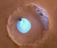 The unnamed impact crater visible within this scene is roughly 35 km wide
and has a maximum depth of approximately 2 km beneath the crater rim. The
circular patch of bright material located at the centre of the crater is
residual water ice. This white patch is present all year round, as
temperature and pressures are not high enough to permit sublimation of water
ice. The composition of the white material cannot be frozen carbon dioxide
since carbon dioxide ice had already disappeared from the North Polar Cap at
the time of image acquisition (late summer of the Martian Northern
Hemisphere). The 0.2 km height difference between the crater floor and the
surface of this bright material cannot be attributed solely to water ice,
but is probably mostly a large dune field lying beneath this ice layer.
Indeed, some of these dunes are exposed at the easternmost edge of the ice.
Faint traces of water ice are also visible along the rim of the crater and on
the crater walls. The absence of ice along the northwest rim and walls may occur
because this area receives more sunlight due to the sunÂ’s orientation, as
highlighted in the perspective view.
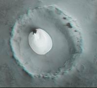 Die Farbansichten wurden aus dem senkrecht blickenden Nadirkanal und den Farbkanälen erstellt, die Schrägansicht wurde aus den Stereokanälen der HRSC berechnet. Die Anaglyphen werden aus dem Nadirkanal und einem Stereokanal abgeleitet. Die schwarzweißen Detailaufnahmen wurden dem Nadirkanal entnommen, der von allen Kanälen die höchste Auflösung zur Verfügung stellt.
The colour scenes have been derived from the three HRSC-colour channels and the nadir channel. The perspective views have been calculated from the digital terrain model derived from the stereo channels. The anaglyph image was calculated from the nadir and one stereo channel. The black and white high resolution images were derived form the nadir channel which provides the highest detail of all channels.
 Das Kameraexperiment HRSC auf der Mission Mars Express der
Europäischen Weltraumorganisation ESA wird vom Principal Investigator Prof. Dr.
Gerhard Neukum (Freie Universität Berlin), der auch die technische Konzeption der
hochauflösenden Stereokamera entworfen hatte, geleitet. Das
Wissenschaftsteam besteht aus 40 Co-Investigatoren aus 33 Institutionen und zehn
Nationen. Die Kamera wurde am Deutschen Zentrum für Luft- und Raumfahrt (DLR) unter der
Leitung des Principal Investigators (PI) G. Neukum entwickelt und in Kooperation mit
industriellen Partnern gebaut (EADS Astrium, Lewicki Microelectronic GmbH und Jena
-Optronik GmbH). Sie wird vom DLR -Institut für Planetenforschung in Berlin-Adlershof
betrieben. Die systematische Prozessierung der Daten erfolgt am DLR. Die Darstellungen
wurden vom Institut für Geologische Wissenschaften der FU Berlin in Zusammenarbeit
mit dem DLR-Institut für Planetenforschung erstellt.
The High Resolution Stereo Camera (HRSC) experiment on the ESA Mars Express Mission is led by the Principal Investigator (PI) Prof. Dr. Gerhard Neukum who also designed the camera technically. The science team of the experiment consists of 40 Co-Investigators from 33 institutions and 10 nations. The camera was developed at the German Aerospace Center (DLR) under the leadership of the PI G. Neukum and built in cooperation with industrial partners (EADS Astrium, Lewicki Microelectronic GmbH and Jena-Optronik GmbH). The experiment on Mars Express is operated by the DLR Institute of Planetary Research, through ESA/ESOC. The systematic processing of the HRSC image data is carried out at DLR. The scenes shown here were created by the PI-group at the Institute for Geological Sciences of the Freie Universitaet Berlin in cooperation with the German Aerospace Center (DLR), Institute of Planetary Research, Berlin.
Download
hochaufgelöste Bilddaten / full resolution image data
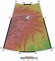
Kontextkarte (MOLA) / Context Map (MOLA) | download TIF ( 2.5 MBs ) |
Nadiraufnahme / Grayscale Nadir Image | download TIF ( 8 MBs ) |
RGB Farbbild / RGB Colour Image | download TIF ( 35.1 MBs ) |
Rot-Cyan Anaglyphe #1 / Red-cyan anaglyphe #1 | download TIF ( 34 MBs ) |
Perspektive / Perspective view | download TIF ( 65.1 MBs ) |

 English

