Navigation/Menü: Links auf weitere Seiten dieser Website und Banner
24.04.2006
HRSC Press Release #253 - Nanedi Valles (orbit 0905)
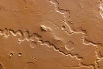
 RGB Farbbild #1 |
On 3 October 2004 the High-Resolution Stereo Camera (HRSC) onboard the ESA spacecraft Mars Express obtained image data in Orbit 905 with a ground resolution of approximately 18 metres per pixel. The data were acquired in the region of Nanedi Valles, at approximately 6.0° northern latitude and 312° eastern longitude.
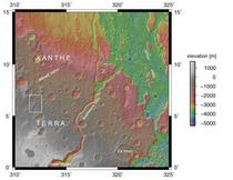
 Kontextkarte |
Nanedi Valles is a Martian valley system, which extends roughly 800 km in a southwest-northeast orientation and is located in the region of Xanthe Terra, southwest of Chryse Planitia. Within the colour image, the valley ranges from approximately 0.8 to 5 km wide and extends to a maximum of about 0.5 km below the surrounding plains. This valley is relatively flat-floored, steep-sloped as well as exhibits meanders and a merging of two branches in the north.
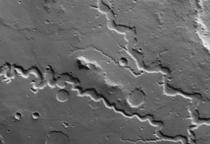
 Nadiraufnahme #1 |
The origin of these striking features remains heavily debated. Some researchers point to sapping (erosion caused by groundwater outflow), while others suggest that flow of liquid beneath an ice cover or collapse of the surface in association with liquid flow is responsible for the valley's formation. While the debate continues, it seems likely that some sort of continuous flow rather than a single flooding event created these features.
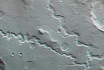
 Rot-Cyan Anaglyphe #1 |
By studying Nanedi Valles, scientists hope to better understand the climatic evolution of the red planet. The HRSC camera supplies new image data for this important region. Further, the stereo and colour capability of the HRSC camera allows for improved study of the planet's morphology, while researchers can analyze reflected light at different wavelengths to better recognize the various geologic units within a scene.
Die Farbansichten wurden aus dem senkrecht blickenden Nadirkanal und den Farbkanälen erstellt, die Schrägansicht wurde aus den Stereokanälen der HRSC berechnet. Die Anaglyphen werden aus dem Nadirkanal und einem Stereokanal abgeleitet. Die schwarzweißen Detailaufnahmen wurden dem Nadirkanal entnommen, der von allen Kanälen die höchste Auflösung zur Verfügung stellt.
The colour scenes have been derived from the three HRSC-colour channels and the nadir channel. The
perspective views have been calculated from the digital terrain model derived from the
stereo channels. The anaglyph image was calculated from the nadir and one stereo channel.
The black and white high resolution images were derived form the nadir channel which provides the
highest detail of all channels.
Das Kameraexperiment HRSC auf der Mission Mars Express der
Europäischen Weltraumorganisation ESA wird vom Principal Investigator Prof. Dr.
Gerhard Neukum (Freie Universität Berlin), der auch die technische Konzeption der
hochauflösenden Stereokamera entworfen hatte, geleitet. Das
Wissenschaftsteam besteht aus 40 Co-Investigatoren aus 33 Institutionen und zehn
Nationen. Die Kamera wurde am Deutschen Zentrum für Luft- und Raumfahrt (DLR) unter der
Leitung des Principal Investigators (PI) G. Neukum entwickelt und in Kooperation mit
industriellen Partnern gebaut (EADS Astrium, Lewicki Microelectronic GmbH und Jena
-Optronik GmbH). Sie wird vom DLR -Institut für Planetenforschung in Berlin-Adlershof
betrieben. Die systematische Prozessierung der Daten erfolgt am DLR. Die Darstellungen
wurden vom Institut für Geologische Wissenschaften der FU Berlin in Zusammenarbeit
mit dem DLR-Institut für Planetenforschung erstellt.
The High Resolution Stereo Camera (HRSC) experiment on the ESA Mars Express Mission is led by the
Principal Investigator (PI) Prof. Dr. Gerhard Neukum who also designed the camera technically. The
science team of the experiment consists of 40 Co-Investigators from 33 institutions and 10 nations.
The camera was developed at the German
Aerospace Center (DLR) under
the leadership of the PI G. Neukum and built in cooperation with industrial partners (EADS
Astrium, Lewicki Microelectronic GmbH and Jena-Optronik GmbH). The experiment on Mars Express
is operated by the DLR Institute of Planetary Research, through ESA/ESOC. The systematic
processing of the HRSC image data is carried out at DLR. The scenes shown here were created
by the PI-group at the Institute for Geological Sciences of the Freie Universitaet Berlin in
cooperation with the German Aerospace Center (DLR), Institute of Planetary Research, Berlin.
Download
hochaufgelöste Bilddaten / high resolution image data
| Kontextkarte: |
| Nadiraufnahme #1: |
| RGB Farbbild #1: |
| Rot-Cyan Anaglyphe #1: |
© Copyright: ESA/DLR/FU Berlin (G. Neukum)

 English

