12.03.2008
HRSC Produktserie #368 - Promethei Planum Orbit 2169
HRSC Press Release #368 - Promethei Planum (orbit 2169)
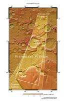
Am 22. September 2005 nahm die hochauflösende Stereokamera (HRSC), unter der Leitung des Principal Investigator Prof. Dr. Gerhard Neukum von der Freien Universität Berlin, auf der ESA-Sonde Mars Express im Orbit 2169 einen Teil der Region Promethei Planum mit einer Auflösung von ca. 40 Metern pro Bildpunkt auf. Die Abbildungen zeigen hiervon einen Ausschnitt bei 76° südlicher Breite und 105° östlicher Länge.
On 22 September 2005 the High-Resolution Stereo Camera (HRSC), under the leadership of the Principal Investigator Prof. Dr. Gerhard Neukum of Freie Universitaet Berlin, onboard the ESA spacecraft Mars Express obtained image data in orbit 2169 with a ground resolution of approximately 40 meters per pixel. The data were acquired in the region of Promethei Planum at approximately 76° southern latitude and 105° eastern longitude.
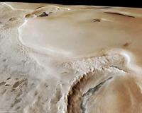
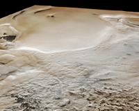
Im nördlichen Teil der Szene befindet sich ein etwa 100 Kilometer großer Einschlagskrater (1). Das Innere des 800 Meter tiefen Kraters ist teilweise von Eis bedeckt. Südlich des Kraters, etwa in der Bildmitte, sind deutlich die Strukturen eines vermutlich basaltischen Lavastroms zu erkennen, der teilweise von Schnee oder Reif überdeckt ist (2). Die dunklen, fast schwarz erscheinenden Dünen bestehen höchstwahrscheinlich aus Gesteinsstaub dieses Lavastroms oder aus vulkanischer Asche (3).
The northern part of the image exhibits an approximately 100 kilometres large impact crater (1). The interior of the 800 meters deep crater is partly covered by ice. Structures of a, presumably basaltic, lava flow are clearly visible south of the crater, almost in the image centre (2). It is partly covered with snow or frost. The dark-coloured dunes are most likely made up of dust originating from this lava flow or volcanic ash (3).
Südlich des Lavastroms erhebt sich ein ausgedehntes Eisfeld. Deutlich ist an der steilen Kante weißes, sauberes Eis zu erkennen (4). Die Eiskappe erreicht hier eine Mächtigkeit zwischen 900 und 1100 Metern.
A broad ice shield is located south of the lava flow. The steep flanks clearly exhibit white, clean ice (4). The thickness of the ice shield is between 900 and 1100 meters.
Neueste Daten des MARSIS Experiments an Bord der ESA Raumsonde Mars Express haben gezeigt, dass die Mächtigkeit der Eiskappe am Südpol stellenweise mehr als 3500 Meter erreicht. Zusammen mit der Eiskappe des Nordpols bildet sie das größte heutige Wasservorkommen des Mars.
Newest data of the MARSIS Experiment onboard the European “Mars Express&rdquro; spacecraft revealed that the thickness of the South Pole ice shield exceeds 3500 meters. Including the North Pole ice shield, the polar caps compose the largest water reservoir on Mars today.
Würde dieses Eis abschmelzen, so wäre die gesamte Oberfläche des Mars von einer mehr als 11 Meter tiefen Wasserschicht bedeckt.
If polar ice melted, the entire surface of Mars would be covered by an ocean eleven meters deep.
Die Farbansichten wurden aus dem senkrecht blickenden Nadirkanal und den Farbkanälen erstellt, die Schrägansichten wurden aus den Stereokanälen der HRSC berechnet. Die Anaglyphe wird aus dem Nadirkanal und einem Stereokanal abgeleitet. Die schwarzweißen Aufnahmen wurden dem Nadirkanal entnommen, der von allen Kanälen die höchste Auflösung zur Verfügung stellt.
The colour scenes have been derived from the three HRSC-colour channels and the nadir channel. The perspective views have been calculated from the digital terrain model derived from the stereo channels. The anaglyph image was calculated from the nadir and one stereo channel. The black and white images were derived from the nadir channel which provides the highest detail of all channels.
Das Kameraexperiment HRSC auf der Mission Mars Express der
Europäischen Weltraumorganisation ESA wird vom Principal Investigator Prof. Dr.
Gerhard Neukum (Freie Universität Berlin), der auch die technische Konzeption der
hochauflösenden Stereokamera entworfen hatte, geleitet. Das
Wissenschaftsteam besteht aus 40 Co-Investigatoren aus 33 Institutionen und zehn
Nationen. Die Kamera wurde am Deutschen Zentrum für Luft- und Raumfahrt (DLR) unter der
Leitung des Principal Investigators (PI) G. Neukum entwickelt und in Kooperation mit
industriellen Partnern gebaut (EADS Astrium, Lewicki Microelectronic GmbH und Jena
-Optronik GmbH). Sie wird vom DLR -Institut für Planetenforschung in Berlin-Adlershof
betrieben. Die systematische Prozessierung der Daten erfolgt am DLR. Die Darstellungen
wurden vom Institut für Geologische Wissenschaften der FU Berlin in Zusammenarbeit
mit dem DLR-Institut für Planetenforschung erstellt.
The High Resolution Stereo Camera (HRSC) experiment on the ESA Mars Express Mission is led by the
Principal Investigator (PI) Prof. Dr. Gerhard Neukum who also designed the camera technically. The
science team of the experiment consists of 40 Co-Investigators from 33 institutions and 10 nations.
The camera was developed at the German
Aerospace Center (DLR) under
the leadership of the PI G. Neukum and built in cooperation with industrial partners (EADS
Astrium, Lewicki Microelectronic GmbH and Jena-Optronik GmbH). The experiment on Mars Express
is operated by the DLR Institute of Planetary Research, through ESA/ESOC. The systematic
processing of the HRSC image data is carried out at DLR. The scenes shown here were created
by the PI-group at the Institute for Geological Sciences of the Freie Universitaet Berlin in
cooperation with the German Aerospace Center (DLR), Institute of Planetary Research, Berlin.
Download
hochaufgelöste Bilddaten / high resolution image data
© Copyright: ESA/DLR/FU Berlin (G. Neukum)


 Deutsch

