Navigation/Menü: Links auf weitere Seiten dieser Website und Banner
15.07.2005
HRSC Press Release #197 - Nicholson Crater (orbit 1104)
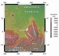 Am 27 November 2004 nahm die hochauflösende Stereokamera (HRSC) auf der ESA
-Sonde Mars Express im Orbit 1104 im Gebiet von Amazonis Planitia die nähere
Umgebung des Nicholson Kraters mit einer Auflösung von etwa 15 Metern pro
Bildpunkt auf. Die Abbildungen zeigen hiervon einen Ausschnitt am Äquator bei
195° östlicher Länge.
On 27 November 2004 the High-Resolution Stereo Camera (HRSC) onboard the ESA
spacecraft Mars Express obtained image data in orbit 1104 with a ground
resolution of approximately 15.3 metres per pixel. The data were acquired in the
region of Nicholson Crater, at approximately 0.0° southern latitude and 195.5°
eastern longitude.
 Der Nicholson Krater misst etwa 100 km im Durchmesser und liegt nordwestlich der
Region Medusae Fossae. Im Zentrum des Kraters befindet sich eine etwa 55 km
lange und 37 km breite Erhebung, die bis zu dreieinhalb Kilometer über der
Umgebung aufragt.
Nicholson Crater, measuring approximately 100 km wide, is located at the
southern edge of Amazonis Planitia, northwest of a region called Medusae Fossae.
Located in the centre of this crater is a raised feature, approximately 55 km
long and 37 km wide, which extends to a maximum height of roughly 3.5 km above
the floor of the crater.
 Bis heute ist noch völlig unklar, um was es sich bei dieser zentralen Struktur
handelt und welcher Prozeß zur Bildung dieser Form geführt hat. Es wird
kontrovers diskutiert, ob es sich um einen Prozeß aus dem Untergrund oder um
Material aus der Atmosphäre handelte. In der Anaglyphe wird deutlich, daß diese
Form aus mehreren stark abgerundeten Einzelerhebungen aufgebaut ist. Ob sich
dies zu Beginn ausgebildet hat oder erst durch die Erosion derartig
herauspräpariert wurde, ist ebenfalls unsicher.
Up to now, it is unclear how this central form was shaped and what kind of
processes led to its formation. It is widely discussed whether the remnant hill
is composed of material from underground or was built as a result of atmospheric
deposition. The peak structure in the center of this hill is the central peak of
the crater, which forms when the ground rebounds after being compressed by the formation of the impact crater.
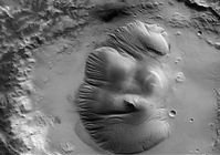 Die spitze Erhebung im Zentrum der Struktur ist der zentrale Restberg des
Kraters (central peak), der sich bei einem Einschlag durch das „Zurückfedern”
verdrängten Materials bildet.
However, it is clear that this feature has been heavily sculpted subsequent to
emplacement by the action of wind or even water.
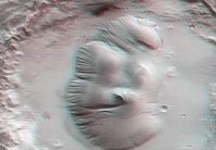 Die Farbansichten wurden aus dem senkrecht blickenden Nadirkanal und den Farbkanälen erstellt, die Schrägansicht wurde aus den Stereokanälen der HRSC berechnet. Die Anaglyphen werden aus dem Nadirkanal und einem Stereokanal abgeleitet. Die schwarzweißen Detailaufnahmen wurden dem Nadirkanal entnommen, der von allen Kanälen die höchste Auflösung zur Verfügung stellt.
The colour scenes have been derived from the three HRSC-colour channels and the nadir channel. The perspective views have been calculated from the digital terrain model derived from the stereo channels. The anaglyph image was calculated from the nadir and one stereo channel. The black and white high resolution images were derived form the nadir channel which provides the highest detail of all channels.
 Das Kameraexperiment HRSC auf der Mission Mars Express der
Europäischen Weltraumorganisation ESA wird vom Principal Investigator Prof. Dr.
Gerhard Neukum (Freie Universität Berlin), der auch die technische Konzeption der
hochauflösenden Stereokamera entworfen hatte, geleitet. Das
Wissenschaftsteam besteht aus 40 Co-Investigatoren aus 33 Institutionen und zehn
Nationen. Die Kamera wurde am Deutschen Zentrum für Luft- und Raumfahrt (DLR) unter der
Leitung des Principal Investigators (PI) G. Neukum entwickelt und in Kooperation mit
industriellen Partnern gebaut (EADS Astrium, Lewicki Microelectronic GmbH und Jena
-Optronik GmbH). Sie wird vom DLR -Institut für Planetenforschung in Berlin-Adlershof
betrieben. Die systematische Prozessierung der Daten erfolgt am DLR. Die Darstellungen
wurden vom Institut für Geologische Wissenschaften der FU Berlin in Zusammenarbeit
mit dem DLR-Institut für Planetenforschung erstellt.
 The High Resolution Stereo Camera (HRSC) experiment on the ESA Mars Express Mission is led by the
Principal Investigator (PI) Prof. Dr. Gerhard Neukum who also designed the camera technically. The
science team of the experiment consists of 40 Co-Investigators from 33 institutions and 10 nations.
The camera was developed at the German
Aerospace Center (DLR) under
the leadership of the PI G. Neukum and built in cooperation with industrial partners (EADS
Astrium, Lewicki Microelectronic GmbH and Jena-Optronik GmbH). The experiment on Mars Express
is operated by the DLR Institute of Planetary Research, through ESA/ESOC. The systematic
processing of the HRSC image data is carried out at DLR. The scenes shown here were created
by the PI-group at the Institute for Geological Sciences of the Freie Universitaet Berlin in
cooperation with the German Aerospace Center (DLR), Institute of Planetary Research, Berlin.
Download
hochaufgelöste Bilddaten / full resolution image data
| Kontextkarte (MOLA) / Context Map (MOLA) | download TIF ( 8.3 MBs ) |
| Aufnahmestreifen / Image Footprint | download TIF ( 4.8 MBs ) |
| Nadiraufnahme / Grayscale Nadir Image | download TIF ( 37.4 MBs ) |
| RGB Farbbild / RGB Colour Image | download TIF ( 113.6 MBs ) |
| Rot-Cyan Anaglyphe #1 / Red-cyan anaglyphe #1 | download TIF ( 103.4 MBs ) |
| Rot-Cyan Anaglyphe #2 / Red-cyan anaglyphe #2 | download TIF ( 13 MBs ) |
| Perspektive / Perspective view | download TIF ( 114.3 MBs ) |
| Perspektive #2 / Perspective view #2 | download TIF ( 109.4 MBs ) |

 Deutsch

