Navigation/Menü: Links auf weitere Seiten dieser Website und Banner
15.02.2005
HRSC Press Release #152 - Ophir Chasma (orbit 0334 & 0360)
Melas Chasma, Candor Chasma und Ophir Chasma: Der zentrale Teil der Valles Marineris
Melas Chasma, Candor Chasma, and Ophir Chasma: The Centre of the Valles Marineris Canyon on Mars
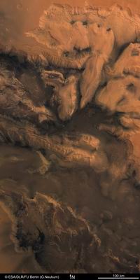 Am 24. April und am 2. Mai 2004 fotografierte die hochauflösende Stereokamera (HRSC) auf
der ESA Sonde Mars Express während der Orbits 334 bzw. 360 den zentralen Teil des
viertausend Kilometer langen Canyons Valles Marineris auf dem Mars. Die Bildauflösung
betrug bei den beiden Aufnahmen 21 bzw. 30 Meter pro Bildpunkt. Die Abbildungen entstammen
einem Mosaik beider Bildsequenzen und zeigen einen etwa 600 Kilometer hohen und 300
Kilometer breiten Ausschnitt zwischen 3° und 13º südlicher Breite bzw. 284º und 289°
östlicher Länge.
On 24 April, and again on 2 May 2004, the High Resolution Stereo Camera (HRSC) on ESA's
Mars Express mission imaged the central part of the four thousand kilometer long Valles
Marineris Canyon during orbits 334 and 360, respectively. The image resolution is 21
metres per pixel for the earlier orbit and 30 metres per pixel for the latter. The scenes
displayed here show an area of approximately 300 by 600 kilometers and are taken from an
image mosaic that was created from the two orbit sequences. This image is located between
3º South and 13º South, and 284º East and 289º East.
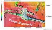 An dieser Stelle haben die in Ost-West-Richtung verlaufenden Täler der Valles Marineris,
die nach ihrer Entdeckung auf den ersten Satellitenbildern der Marssonde Mariner 9 im
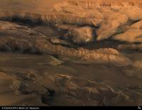
Jahre 1971 benannt wurden, ihre größte Nord-Süd-Ausdehnung. Die perspektivische Ansicht
zeigt den Blick von einem imaginären Punkt oberhalb des angrenzenden Hochlands über die
mittleren Valles Marineris von Süden nach Norden. Dabei sind die drei parallel
verlaufenden Zentraltäler Melas Chasma (lat., die "dunkle Talenge"), Candor Chasma (die
"blasse Talenge") und Ophir Chasma (in der Bibel das Land, in das König Salomon eine
Schiffsexpedition entsandte - vermutlich Indien) zu sehen. Jedes dieser Täler ist etwa 200
Kilometer breit und zwischen fünf und sieben Kilometer tief.
Here, the east-west trending Valles Marineris canyon (named after the American Mariner 9
probe, the first spacecraft to image this enormous feature in 1971) has its largest north
-south extent. The perspective view looks northward from an imaginary point above the
adjoining highlands into the centre of Valles Marineris. The main Marineris valley, named
Melas Chasma (Latin for the "dark chasm"), is situated nearest to the observer, then
Candor Chasma (the "pale chasm") and Ophir Chasma, closest to the horizon (in the bible,
King Salomon sent a ship on an expedition to the land of Ophir, possibly a reference to
present-day India). Each valley is approximately 200 kilometers wide and between five and
seven thousand meters deep.
 Wie diese riesige geologische Struktur entstanden ist, kann immer noch nicht mit
Gewissheit gesagt werden. Möglicherweise führten Spannungen in der Marskruste zu einem
Aufreißen des Hochlands und einem Absinken der Gesteinsschollen zwischen den Bruchlinien.
Dieses Auseinanderbrechen könnte sich ereignet haben, als vor Milliarden Jahren unter der
sich nach Westen erstreckenden Tharsis-Region vulkanische Aktivität einsetze und Tharsis
zu einem mehrere Kilometer hohen langgezogenen Bergrücken aufgewölbt wurde. Auf der Erde
bezeichnet man solche, die Kruste in ihrer ganzen Tiefe durchziehenden Grabenbrüche als
"Rift".
Als Alternative zu diesen "tektonischen" Bewegungen werden Einsturzvorgänge angeführt.
Beispielsweise könnte ein beträchtlicher Anteil von Eis, das möglicherweise ursprünglich
in der Tiefe vorhanden war, geschmolzen sein. Das Wasser wäre in Richtung der großen
Ausflusstäler abgeflossen, die Oberfläche stürzte in die entstandenen Hohlräume nach und
hätte so dieses Talsystem gebildet. Was auch immer der Grund für die Entstehung der Valles
Marineris war, die Wände wurden nach der Absenkung des Geländes stark erodiert.
It remains unclear how this gigantic geologic feature, unparalleled in the Solar System,
formed. Tensions in the upper crust of Mars possibly led to cracking of the highlands.
Subsequently, blocks of the crust slid down between these tectonic fractures. The
fracturing of Valles Marineras could have occurred billions of years ago, when the Tharsis
bulge (located west of Valles Marineris) began to form as the result of volcanic activity
and subsequently grew to the dimensions of greater than one thousand kilometres in
diameter and more than ten kilometres high. On Earth, such a tectonic process is called
rifting, presently occurring on a smaller scale in the Kenya rift in East Africa.
The collapse of large parts of the highland is an alternative explanation. For instance,
extensive amounts of water ice could have been stored beneath the surface and were
subsequently melted as a result of thermal activity, most likely the nearby volcanic
Tharsis province. The water could have travelled in the direction of the northern
lowlands, leaving cavities beneath the surface where the ice once existed. The roofs could
no longer sustain the load of the overlying rocks, so the area collapsed. Regardless of
how Valles Marineris might be formed, it is clear that once the depressions were formed
and the surface was topographically structured, heavy erosion began shaping the landscape.
 Auffallend sind zwei sehr unterschiedliche Geländeformen: Zum einen stark zerklüftete,
schroffe Klippen, und zum anderen im Inneren der Täler langgestreckte Berge, die
"weichere", gerundete Oberflächen haben. Erstere stellen eine typische Erosionsform in
trockenen Gebirgen dar; auch wenn es als gesichert gilt, dass auf dem Mars einst Wasser
geflossen ist oder sich Gletscher über die Oberfläche geschoben haben ist der Mars heute
ein trockener Wüstenplanet. An manchen steilen Talhängen sind Gesteinsschichten zu
erkennen, und man nimmt an, dass einzelne Schichten aus vulkanischen Gesteinen das flache,
von den Valles Marineris durchschnittene Hochland aufbauen. Wie die gerundeten Hügel
entstanden sind, ist unklar.
Unterhalb der nördlichen Geländekante sind gewaltige Hangrutsche zu erkennen, in denen
sich von den Rändern abgebrochenes Material bis zu 70 Kilometer weit in die Täler
geschoben hat. Auch im Bildvordergrund sieht man Strukturen, die darauf schließen lassen,
dass hier in früherer Zeit etwas geflossen ist: Dadurch könnte Material abgelagert worden
sein, das den heute auffallend ebenen Talgrund gestaltet hat. Die an zerbrochene
Eisschollen erinnernde Oberfläche in der Bildmitte wurde bereits auf den Bildern der
amerikanischen Viking-Sonden in den 1970er-Jahren identifiziert; ihr Ursprung gilt auch
heute noch als rätselhaft.
 Two distinct landforms can be distinguished. On one hand, we see sheer cliffs with
prominent edges and ridges. These are erosion features typical in arid mountain zones on
Earth. Today, the surface of Mars is bone dry, so wind and gravity are the dominant
processes that shape the landscape (this might have been much different in the geologic
past of the planet when Valles Marineris possibly had flowing water or glaciers winding
downslope). In contrast, some gigantic "hills" (indeed, between one and two thousand
meters high) located on the floors of the valleys have a smoother topography and a more
sinuous outline. So far, scientists have no definitive explanation for why these different
landforms exist.
Below the northern scarp, there are several landslides, where material was transported
over a distance of up to 70 kilometers. Also, in the image there are several structures
suggesting flow of material in the past. Therefore, material could have been deposited in
the valleys, making the present floor look heterogeneous. In the center of the image,
there are surface features that appear similar to ice flows. These were previously
identified in pictures from the American Viking probes of the 1970s; their origin remains
a mystery.
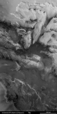
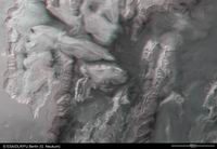
The colour scenes have been derived from the three HRSC-colour channels and the nadir
channel. The perspective views have been calculated from the digital terrain model
derived from the stereo channels. The anaglyph image was calculated from the nadir and
one stereo channel. The black and white high resolution images were derived form the
nadir channel which provides the highest detail of all channels.
 Die Farbdarstellung) wurde aus den Farbkanälen und dem Nadirkanal, dem direkt nach unten blickenden Sensor der HRSC, erstellt. Das Anaglyphenbild, das bei Verwendung einer Rot-Blau- oder einer
Rot-Grün-Brille einen dreidimensionalen Eindruck der Oberfläche liefert, und die
perspektivische Ansichten, wurden
aus dem Nadirkanal und den Stereokanälen berechnet. Für die Darstellung im Internet wurde
die Originalauflösung der Bilddaten verringert.
Aus technischen Gründen mußte für die Anaglyphendarstellungen das Bild gedreht werden, so dass hier Norden links ist.
The colour scenes have been derived from the three HRSC-colour channels and the nadir channel. The perspective views have been calculated from the digital terrain model derived from the stereo channels. The anaglyph image was calculated from the nadir and one stereo channel. The black and white high resolution images were derived form the nadir channel which provides the highest detail of all channels.
Das Kameraexperiment HRSC auf der Mission Mars Express der Europäischen Weltraumorganisation ESA wird vom Principal Investigator Prof. Dr. Gerhard Neukum (Freie Universität Berlin), der auch die technische Konzeption der hochauflösenden Stereokamera entworfen hatte, geleitet. Das Wissenschaftsteam besteht aus 40 Co-Investigatoren aus 33 Institutionen und zehn Nationen. Die Kamera wurde am Deutschen Zentrum für Luft- und Raumfahrt (DLR) unter der Leitung des Principal Investigators (PI) G. Neukum entwickelt und in Kooperation mit industriellen Partnern gebaut (EADS Astrium, Lewicki Microelectronic GmbH und Jena -Optronik GmbH). Sie wird vom DLR -Institut für Planetenforschung in Berlin-Adlershof betrieben. Die systematische Prozessierung der Daten erfolgt am DLR. Die Darstellungen wurden vom Institut für Geologische Wissenschaften der FU Berlin in Zusammenarbeit mit dem DLR-Institut für Planetenforschung erstellt.
The High Resolution Stereo Camera (HRSC) experiment on the ESA Mars Express Mission is led by the Principal Investigator (PI) Prof. Dr. Gerhard Neukum who also designed the camera technically. The science team of the experiment consists of 40 Co-Investigators from 33 institutions and 10 nations. The camera was developed at the German Aerospace Center (DLR) under the leadership of the PI G. Neukum and built in cooperation with industrial partners (EADS Astrium, Lewicki Microelectronic GmbH and Jena-Optronik GmbH). The experiment on Mars Express is operated by the DLR Institute of Planetary Research, through ESA/ESOC. The systematic processing of the HRSC image data is carried out at DLR. The scenes shown here were created by the PI-group at the Institute for Geological Sciences of the Freie Universitaet Berlin in cooperation with the German Aerospace Center (DLR), Institute of Planetary Research, Berlin.
© Copyright: ESA/DLR/FU Berlin (G. Neukum)
Download
hochaufgelöste Bilddaten / full resolution image data
| Kontextkarte (MOLA) / Context Map (MOLA) | download TIF ( 3.8 MBs ) |
| Aufnahmestreifen / Image Footprint | download TIF ( 25.7 MBs ) |
| Nadiraufnahme / Grayscale Nadir Image | download TIF ( 68.7 MBs ) |
| RGB Farbbild / RGB Colour Image | download TIF ( 206 MBs ) |
| Rot-Cyan Anaglyphe / Red-cyan anaglyphe | download TIF ( 71.2 MBs ) |
| Perspektive / Perspective view | download TIF ( 79.8 MBs ) |

 Deutsch

