Navigation/Menü: Links auf weitere Seiten dieser Website und Banner
22.12.2004
HRSC Press Release #143 - Candor Chasma (orbit 0360)
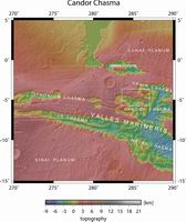
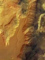 Am 2. Mai 2004 nahm die hochauflösende Stereokamera (HRSC) auf der ESA Sonde
Mars Express im Orbit 360 das Gebiet Candor Chasma im Talsystem Valles
Marineris mit einer Auflösung von etwa 40 Metern pro Bildpunkt auf. Die
Abbildungen zeigen hiervon einen Ausschnitt bei 5° südlicher Breite und 285°
östlicher Länge.
On 29 June 2004 the High Resolution Stereo Camera (HRSC) onboard the ESA spacecraft Mars Express obtained image data in orbit 563 with a ground resolution of approximately 62 metres per pixel. The images cover Claritas Fossae at approximately 25° southern latitude and 253° eastern longitude.
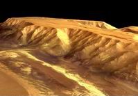 Das Bild zeigt die seitliche Wand von Candor Chasma, einem der größten Täler der
Valles Marineris. Erosionsprozesse haben Spuren an der Wand hinterlassen, die
man in dieser Form auf der Erde vor allem in ariden (sehr trockenen) oder
alpinen Regionen findet. Das Hochplateau, das Candor Chasma umgrenzt, ist fast
vollkommen flach. Man geht davon aus, daß es aus vielen Lagen basaltischer Lava
besteht. Die Wand ist etwa 6 km hoch. Derzeit ist nicht geklärt, welche Prozesse
verantwortlich für diesen enormen Höhenunterschied waren. Möglicherweise führten
Dehnungsspannungen in der Marskruste zum Auseinanderbrechen der
Gesteinsschichten und dem Absinken des Talbodens. Ein Tal, das durch eine
derartige Absenkung einer länglichen Senke durch Tektonik entsteht, bezeichnet
man als (tektonischen) Graben.
Ziehen sich die Brüche, die einen Graben
begrenzen, durch die gesamte Lithosphäre, also die elastische äußere
Gesteinsschicht eines Planeten, spricht man von einem Rift. Tatsächlich wurden
die Valles Marineris bereits als Rift interpretiert. Eine alternative zu
tektonischen Bewegungen wären Einsturzvorgänge. Ein terrestrisches Beispiel ist
Karst: Hier wird Karbonatgestein im Untergrund durch Wasser gelöst, und es
entstehen Hohlräume. Wenn die Decke einer derartigen Karsthöhle einstürzt,
entsteht eine Doline. Auf dem Mars wurden bisher keine großen Karbonatvorkommen
entdeckt. Vielleicht könnte es aber infolge anderer Prozesse zum Verlust von
Material im Untergrund gekommen sein, worauf die Valles Marineris als
Einsturzstrukturen entstanden wären. Beispielsweise könnte ein beträchtlicher
Anteil von Eis, der möglicherweise ursprünglich in der Tiefe vorhanden gewesen
war, geschmolzen sein. Das Wasser wäre in Richtung der großen Ausflusstäler
abgeflossen, und die Oberfläche hätte sich gesenkt. Was auch immer der Grund für
die Entstehung der Valles Marineris war, die Wände sind nach der Absenkung des
Geländes stark erodiert worden.
 The images show the walls of Candor Chasma, which is one of the largest canyons
in the Valles Marineris canyon system. Traces of erosion can be observed at the
canyon walls, which are similar to erosional features observed on Earth in arid
or alpine regions. The high standing plateaus, which have an elevation of
approximately 6 km, have a very flat surface and most likely consist of several
layers of basaltic lava. While what caused the formation of the canyon system
remains unclear, it seems probable that tension and fracturing of the upper
crust caused widening of the canyon and subsequent lowering of the valley floor
(a so-called tectonic graben). Valles Marineris has also been interpreted as a
possible rift, which occurs when tensional fractures extend deeper than the
elastic lithosphere.
An alternate theory on the formation of the canyon system is the removal of rock
material from the subsurface, as a result of the activity of water, and
subsequent collapse of the surface. This process is analogous to the formation
of terrestrial karst landscapes. It could also be possible that large amounts of
ice in the subsurface melted and this melt water formed the large outflow
channels in the north. As a result, the surface collapsed where substantial
amounts of ice were removed, forming the Valles Marineris system as we see it
today.
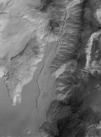
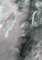 Die Farbansichten wurden aus dem senkrecht blickenden Nadirkanal und den Farbkanälen erstellt, die Schrägansicht wurde aus den Stereokanälen der HRSC berechnet. Die Anaglyphen werden aus dem Nadirkanal und einem Stereokanal abgeleitet. Die schwarzweißen Detailaufnahmen wurden dem Nadirkanal entnommen, der von allen Kanälen die höchste Auflösung zur Verfügung stellt.
The colour scenes have been derived from the three HRSC-colour channels and the nadir channel. The perspective views have been calculated from the digital terrain model derived from the stereo channels. The anaglyph image was calculated from the nadir and one stereo channel. The black and white high resolution images were derived form the nadir channel which provides the highest detail of all channels.
Das Kameraexperiment HRSC auf der Mission Mars Express der Europäischen Weltraumorganisation ESA wird vom Principal Investigator Prof. Dr. Gerhard Neukum (Freie Universität Berlin), der auch die technische Konzeption der hochauflösenden Stereokamera entworfen hatte, geleitet. Das Wissenschaftsteam besteht aus 40 Co-Investigatoren aus 33 Institutionen und zehn Nationen. Die Kamera wurde am Deutschen Zentrum für Luft- und Raumfahrt (DLR) unter der Leitung des Principal Investigators (PI) G. Neukum entwickelt und in Kooperation mit industriellen Partnern gebaut (EADS Astrium, Lewicki Microelectronic GmbH und Jena -Optronik GmbH). Sie wird vom DLR -Institut für Planetenforschung in Berlin-Adlershof betrieben. Die systematische Prozessierung der Daten erfolgt am DLR. Die Darstellungen wurden vom Institut für Geologische Wissenschaften der FU Berlin in Zusammenarbeit mit dem DLR-Institut für Planetenforschung erstellt.
 The High Resolution Stereo Camera (HRSC) experiment on the ESA Mars Express Mission is led by the
Principal Investigator (PI) Prof. Dr. Gerhard Neukum who also designed the camera technically. The
science team of the experiment consists of 40 Co-Investigators from 33 institutions and 10 nations.
The camera was developed at the German
Aerospace Center (DLR) under
the leadership of the PI G. Neukum and built in cooperation with industrial partners (EADS
Astrium, Lewicki Microelectronic GmbH and Jena-Optronik GmbH). The experiment on Mars Express
is operated by the DLR Institute of Planetary Research, through ESA/ESOC. The systematic
processing of the HRSC image data is carried out at DLR. The scenes shown here were created
by the PI-group at the Institute for Geological Sciences of the Freie Universitaet Berlin in
cooperation with the German Aerospace Center (DLR), Institute of Planetary Research, Berlin.
© Copyright: ESA/DLR/FU Berlin (G. Neukum)
Download
hochaufgelöste Bilddaten / full resolution image data
| Kontextkarte (MOLA) / Context Map (MOLA) | download TIF ( 4.6 MBs ) |
| Nadiraufnahme / Grayscale Nadir Image | download TIF ( 27.8 MBs ) |
| RGB Farbbild / RGB Colour Image | download TIF ( 82 MBs ) |
| Rot-Cyan Anaglyphe / Red-cyan anaglyphe | download TIF ( 109.8 MBs ) |
| Perspektive / Perspective view | download TIF ( 50.6 MBs ) |

 Deutsch

